Los Angeles County, CA Elevation & Topographic Map
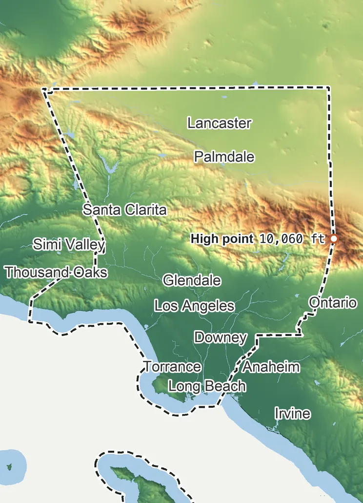
Elevation
10,060 ft 3,065 m7,550 ft 2,300 m6,290 ft 1,915 m3,770 ft 1,150 m1,260 ft 385 m0 ft 0 m
Zoom in for contour lines
USGS 3DEP · U.S. Census Bureau
How to use this mapviews, tools and data
- Elevation
- Ground colored by height from green (lowest) to white (highest), with contour lines every 40–500 ft (USGS data).
- Satellite
- A 2016 satellite photo at 33 ft (10 m) detail; contours off.
- 3D
- Tilt and turn the terrain; hills are raised 1.5×, or set ×1 for true height.
- Click or tap anywhere
- The exact elevation of that spot in ft and m.
- Measure
- Pick two points for the climb, descent and grade along a straight line.
- County area
- Fades everything outside the official county boundary (US Census).
Elevation Data
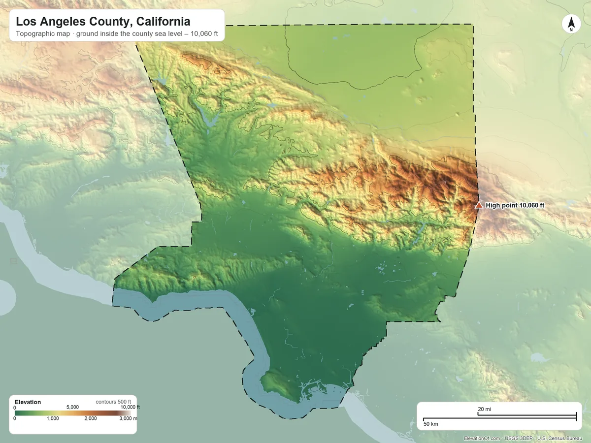
Los Angeles County averages about 2,250 ft (685 m) above sea level across all its land. Its ground runs from sea level on the Pacific Ocean to 10,060 ft on Mount San Antonio.
Average elevation
2,250 ft 685 m
all land inside the county
Highest
10,060 ft 3,065 m
on Mount San Antonio
Lowest
0 ft 0 m
at sea level on the Pacific Ocean
Los Angeles County spans about 10,060 ft of height, so no single spot tells the whole story. The ruler shows where most of its land lies, and where the other numbers you'll see come from.
| Figure | Elevation |
|---|---|
| Average of all land | 2,250 ft685 m |
| Highest point Inside the county, on Mount San Antonio (3DEP terrain model; no NGS survey height) | 10,060 ft3,065 m |
| Lowest point Where the land meets the Pacific Ocean | 0 ft0 m |
Elevation profile, south to north
105 mi south to north through Los Angeles.
Topographic Map
- Location
- County in California, United States
- Population
- 9,757,179 2024 est.
- Land area
- 4,060.3 sq mi + 689.1 sq mi water
- Density
- 2,403 per sq mi
- Time zone
- Pacific UTC−8 / −7
- Landform regions
- Pacific Border 76%, Basin and Range 23%
- Drains to
- Pacific Ocean 71%, Rosamond Lake basin (does not reach the sea) 21%
⤓ Download this map
WebP, 1200 × 900. Free to use: credit “ElevationOf.com” with a link to this page.
Sources: U.S. Census Bureau, USGS
Nearby Places
Neighboring counties sharing a border, by average
- San Bernardino County2,660 ft
- Ventura County2,650 ft
- Kern County2,390 ft
- Los Angeles County2,250 ft
- Orange County700 ft
Rankings by average elevation
- Counties in California25th highest of 57
- Counties in the United States544th highest of 3,151
Peaks and hills highest inside
- Mount San Antonio10,060 ft
- Mount Baden-Powell9,390 ft
- Mount Williamson8,240 ft
- Waterman Mountain8,030 ft
- Pacifico Mountain7,137 ft
All 142 towns in Los Angeles County by typical elevation
- Leona Valley3,450 ft
- Lake Hughes3,410 ft
- Elizabeth Lake3,380 ft
- Acton3,240 ft
- Green Valley, Los Angeles County3,000 ft
- Littlerock2,880 ft
- Sun Village2,730 ft
- Desert View Highlands2,720 ft
- Agua Dulce2,720 ft
- Palmdale2,680 ft
- Lake Los Angeles2,660 ft
- Quartz Hill2,470 ft
- Lancaster2,380 ft
- La Crescenta-Montrose1,610 ft
- Hasley Canyon1,530 ft
- Stevenson Ranch1,500 ft
- La Cañada Flintridge1,480 ft
- Santa Clarita1,380 ft
- Castaic1,280 ft
- Val Verde1,270 ft
- Claremont1,260 ft
- Topanga1,240 ft
- Altadena1,210 ft
- La Verne1,130 ft
- Hidden Hills1,130 ft
- San Fernando1,110 ft
- Calabasas1,090 ft
- Agoura Hills970 ft
- Rolling Hills970 ft
- San Dimas960 ft
- Westlake Village930 ft
- Diamond Bar920 ft
- Sierra Madre890 ft
- Pasadena870 ft
- Pomona860 ft
- Glendora790 ft
- Bradbury780 ft
- Rancho Palos Verdes760 ft
- Charter Oak720 ft
- San Pasqual700 ft
- La Habra Heights670 ft
- Walnut660 ft
- South Pasadena650 ft
- East Pasadena630 ft
- Burbank620 ft
- Azusa600 ft
- Citrus590 ft
- Glendale580 ft
- San Marino570 ft
- Rose Hills570 ft
- Covina560 ft
- Rolling Hills Estates560 ft
- Duarte540 ft
- Monrovia530 ft
- Rowland Heights530 ft
- East San Gabriel490 ft
- Arcadia470 ft
- Vincent470 ft
- Alhambra460 ft
- Hacienda Heights450 ft
- Irwindale450 ft
- Pepperdine University450 ft
- West Covina440 ft
- South San Jose Hills440 ft
- Palos Verdes Estates410 ft
- South Monrovia Island390 ft
- San Gabriel390 ft
- Monterey Park390 ft
- Valinda380 ft
- Los Angeles370 ft
- Temple City360 ft
- Mayflower Village360 ft
- Baldwin Park360 ft
- South San Gabriel340 ft
- North El Monte330 ft
- La Puente330 ft
- West Puente Valley320 ft
- Industry320 ft
- Avocado Heights300 ft
- Rosemead300 ft
- View Park-Windsor Hills290 ft
- El Monte290 ft
- West Hollywood280 ft
- Whittier270 ft
- East Whittier250 ft
- South El Monte240 ft
- East Los Angeles230 ft
- Beverly Hills220 ft
- Montebello210 ft
- West Athens190 ft
- Malibu190 ft
- Westmont190 ft
- Ladera Heights170 ft
- Pico Rivera170 ft
- South Whittier160 ft
- West Whittier-Los Nietos160 ft
- Huntington Park160 ft
- Maywood160 ft
- Vernon150 ft
- Commerce150 ft
- Santa Monica150 ft
- La Mirada150 ft
- Walnut Park150 ft
- Florence-Graham140 ft
- Bell140 ft
- Santa Fe Springs140 ft
- Cudahy130 ft
- Manhattan Beach130 ft
- Bell Gardens130 ft
- Inglewood120 ft
- El Segundo120 ft
- West Rancho Dominguez110 ft
- Downey110 ft
- Redondo Beach110 ft
- South Gate110 ft
- Signal Hill100 ft
- Lomita92 ft
- Norwalk91 ft
- Del Aire88 ft
- Torrance88 ft
- Avalon86 ft
- Lynwood86 ft
- Willowbrook83 ft
- Lennox79 ft
- Hermosa Beach79 ft
- Compton74 ft
- Paramount74 ft
- Bellflower72 ft
- East Rancho Dominguez69 ft
- Hawthorne67 ft
- Culver City66 ft
- Lawndale62 ft
- Artesia55 ft
- Cerritos54 ft
- Alondra Park53 ft
- Lakewood51 ft
- Gardena51 ft
- West Carson41 ft
- Long Beach39 ft
- Carson35 ft
- Hawaiian Gardens32 ft
- Marina del Rey23 ft
How we measure
- Average: every USGS 3DEP bare-earth cell of land inside the Census county boundary (TIGER/Line, Jan 1 2026), weighted equally, on a 3 arc-second (≈300 ft, 93 m) grid, coarsened from 1 arc-second so the whole area fits one run. Land means the boundary minus Census area water (on this grid, water areas of at least half a cell).
- Highest and lowest: the highest land cell, re-read at 1 arc-second around the 25 highest grid cells; it is a named summit, so its height is the peak method: the 3DEP top on a ~7 ft (2 m) window, or the NGS published height when a survey mark sits within 160 ft (50 m) of it. Lowest: the lowest land cell, re-read at 1 arc-second around the 25 lowest grid cells; coastal ground within 3 ft (1 m) of named tidal water counts as sea level.
- Pits: the lowest point is the lowest ground outside closed hollows (quarry floors, mine pits, terrain-model artifacts): any hollow under 0.4 sq mi (1 km²), and any hollow under 2 sq mi (5 km²) whose floor is more than 100 ft (30 m) below its rim; and outside patches below sea level of under 0.4 sq mi (1 km²). The single lowest 3DEP cell, −16 ft at 33.7638° N, 118.2290° W, is in such a hollow or patch and is not counted; this coastal land's lowest point is sea level on the coast.
- Nearby Places: neighboring counties and rankings use each one's average elevation, on its own grid, the same figure its page shows. Peaks and hills: the highest summits inside the county with at least 980 ft (300 m) of prominence, then the highest federal (GNIS) summits inside it when there are fewer than 5; each is the 3DEP top on a ~7 ft (2 m) window, or the NGS published height when a usable survey mark sits within 160 ft (50 m) of it (shown as published).
- Towns: each town's typical elevation (population-weighted median of its own 2020 blocks at 1 arc-second); a town is listed when any of its 2020 residents live in the county.
- Rounding: computed heights are rounded to 10 ft (5 m), or to 1 ft (1 m) under 100 ft; 3DEP is good to about a meter, not a foot. Published figures (NGS survey heights) are shown as their publisher gives them.
- Datum: North American Vertical Datum of 1988 (NAVD 88). NGS plans to replace NAVD 88 with a new datum (NAPGD2022); heights will then shift slightly.
- Sources: USGS 3DEP, GNIS, Watershed Boundary Dataset and physiographic provinces; U.S. Census Bureau (TIGER boundaries and water, 2020 blocks, 2024 population estimates, county adjacency); NOAA NGS survey heights; BTS time zones. All public domain.