New York, NY Elevation & Topographic Map
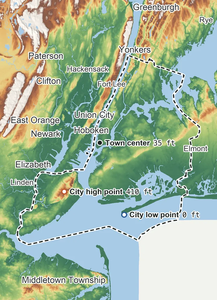
Elevation
410 ft 125 m310 ft 95 m260 ft 80 m150 ft 45 m51 ft 16 m0 ft 0 m
Contours every 500 ft, bold every 2,500 ft
USGS 3DEP · U.S. Census Bureau
How to use this mapviews, tools and data
- Elevation
- Ground colored by height from green (lowest) to white (highest), with contour lines every 40–500 ft (USGS data).
- Satellite
- A 2016 satellite photo at 33 ft (10 m) detail; contours off.
- 3D
- Tilt and turn the terrain; hills are raised 1.5×, or set ×1 for true height.
- Click or tap anywhere
- The exact elevation of that spot in ft and m.
- Measure
- Pick two points for the climb, descent and grade along a straight line.
- City area
- Fades everything outside the official city limits (US Census).
Elevation Data
New York sits at about 46 ft (14 m) above sea level, worked out from 2020 Census block heights on USGS 3DEP, weighted by residents.
Typical elevation
46 ft 14 m
most residents: 13–110 ft
Lowest
0 ft 0 m
at sea level on the Atlantic Ocean
Highest
410 ft 125 m
on the southwest side
Average
52 ft 16 m
all land inside city limits
New York spans about 410 ft of height, so no single spot tells the whole story. The ruler shows where its people live, and where the other numbers you'll see come from.
| Figure | Elevation |
|---|---|
| Typical Where people live: half of residents higher, half lower | 46 ft14 m |
| Highest point Inside city limits, on the southwest side | 410 ft125 m |
| Lowest point Where the land meets the Atlantic Ocean | 0 ft0 m |
| Town center USGS map point for New York | 35 ft11 m |
| Airport (JFK) FAA airport elevation, the highest point of its runways | 13 ft4 m |
| Average of all land | 52 ft16 m |
Elevation profile, south to north
18 mi south to north through the town center.
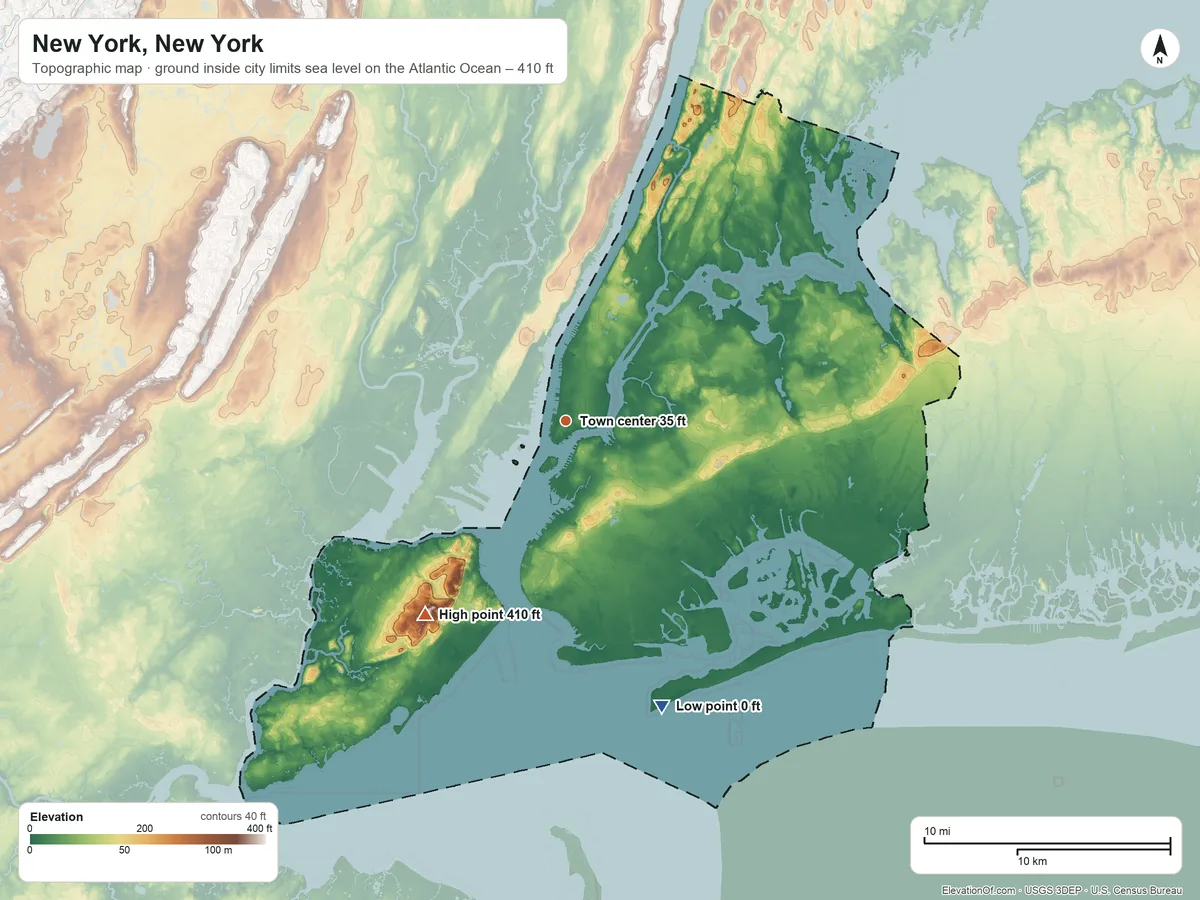
Topographic Map
- Location
- City in Kings, Queens and New York counties and 2 more, New York, United States
- Population
- 8,478,072 2024 est.
- Land area
- 300.5 sq mi + 171.9 sq mi water
- Density
- 28,215 per sq mi
- Coordinates
- 40.7143° N, 74.0060° W
- Time zone
- Eastern UTC−5 / −4
- Landform region
- New England
- Drains to
- Atlantic Ocean
- Airport
- John F Kennedy International (JFK) 13 ft
- ZIP codes 211
211 ZIP codes
10001 10002 10003 10004 10005 10006 10007 10009 10010 10011 10012 10013 10014 10016 10017 10018 10019 10020 10021 10022 10023 10024 10025 10026 10027 10028 10029 10030 10031 10032 10033 10034 10035 10036 10037 10038 10039 10040 10044 10065 10069 10075 10103 10110 10111 10112 10115 10119 10128 10152 10153 10154 10162 10165 10167 10168 10169 10170 10171 10172 10173 10174 10177 10199 10271 10278 10279 10280 10282 10301 10302 10303 10304 10305 10306 10307 10308 10309 10310 10311 10312 10314 10451 10452 10453 10454 10455 10456 10457 10458 10459 10460 10461 10462 10463 10464 10465 10466 10467 10468 10469 10470 10471 10472 10473 10474 10475 11004 11005 11101 11102 11103 11104 11105 11106 11109 11201 11203 11204 11205 11206 11207 11208 11209 11210 11211 11212 11213 11214 11215 11216 11217 11218 11219 11220 11221 11222 11223 11224 11225 11226 11228 11229 11230 11231 11232 11233 11234 11235 11236 11237 11238 11239 11249 11354 11355 11356 11357 11358 11359 11360 11361 11362 11363 11364 11365 11366 11367 11368 11369 11370 11371 11372 11373 11374 11375 11377 11378 11379 11385 11411 11412 11413 11414 11415 11416 11417 11418 11419 11420 11421 11422 11423 11424 11426 11427 11428 11429 11430 11432 11433 11434 11435 11436 11439 11451 11691 11692 11693 11694 11697
⤓ Download this map
WebP, 1200 × 900. Free to use: credit “ElevationOf.com” with a link to this page.
Sources: U.S. Census Bureau, USGS, FAA
Nearby Places
Nearby towns by typical elevation
- Fairview, NJ230 ft
- Guttenberg, NJ190 ft
- Union City, NJ190 ft
- North Bergen Township, NJ180 ft
- West New York, NJ170 ft
- Weehawken Township, NJ160 ft
- Jersey City, NJ55 ft
- New York46 ft
- Bayonne, NJ31 ft
- Secaucus, NJ11 ft
- Hoboken, NJ7 ft
Rankings by typical elevation
- Towns in New York1,957th highest of 2,097
Peaks and hills nearest, by height
- Mount Don Bosco2,290 ft
- South Beacon Mountain1,600 ft
- Inwood Hill230 ft
- Breeze Hill, Kings County190 ft
- Great Hill, New York County130 ft
How we measure
- Typical elevation: the population-weighted median: every 2020 Census block inside the city limits, at its USGS 3DEP height, weighted by the people who live there. Half of residents live higher, half lower.
- Lowest, highest, average: USGS 3DEP bare-earth heights on a 1 arc-second (≈100 ft, 30 m) grid, land only, inside the Census city limits (TIGER, Jan 1 2026).
- Pits: the lowest point is the lowest ground outside closed hollows (quarry floors, mine pits, terrain-model artifacts): any hollow under 0.4 sq mi (1 km²), and any hollow under 2 sq mi (5 km²) whose floor is more than 100 ft (30 m) below its rim; and outside patches below sea level of under 0.4 sq mi (1 km²). The single lowest 3DEP cell, −58 ft at 40.7560° N, 74.0012° W, is in such a hollow or patch and is not counted; this coastal land's lowest point is sea level on the coast.
- Nearby Places: nearby towns and rankings use each town's typical elevation, so every town is compared like for like. Rankings count every city, town, township and census-designated place, including places inside a town. Peaks and hills: the nearest summits with at least 980 ft (300 m) of prominence within 62 mi (100 km), then federal (GNIS) summits within 16 mi (25 km) when there are fewer than 5; each is the 3DEP top on a ~7 ft (2 m) window, or the NGS published height when a usable survey mark sits within 160 ft (50 m) of it (shown as published).
- Rounding: computed heights are rounded to 10 ft (5 m), or to 1 ft (1 m) under 100 ft; 3DEP is good to about a meter, not a foot. Published figures (FAA airport elevation, NGS survey heights) are shown as their publisher gives them.
- Datum: North American Vertical Datum of 1988 (NAVD 88). NGS plans to replace NAVD 88 with a new datum (NAPGD2022); heights will then shift slightly.
- Sources: USGS 3DEP, GNIS, Watershed Boundary Dataset and physiographic provinces; U.S. Census Bureau (boundaries, 2020 blocks, 2024 population estimates, Gazetteer areas, ZIP code areas); FAA airport data; BTS time zones. All public domain.