Fordoche, LA Elevation & Topographic Map
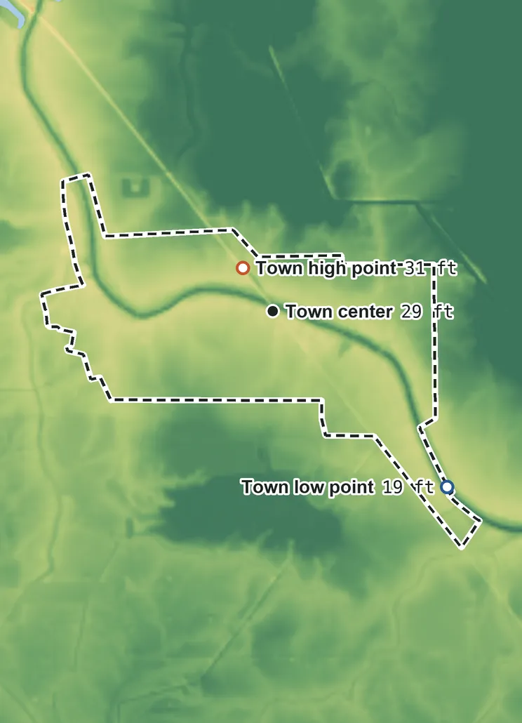
Elevation
52 ft 16 m43 ft 13 m39 ft 12 m31 ft 9 m23 ft 7 m19 ft 6 m
Contours every 100 ft, bold every 500 ft
USGS 3DEP · U.S. Census Bureau
How to use this mapviews, tools and data
- Elevation
- Ground colored by height from green (lowest) to white (highest), with contour lines every 40–500 ft (USGS data).
- Satellite
- A 2016 satellite photo at 33 ft (10 m) detail; contours off.
- 3D
- Tilt and turn the terrain; hills are raised 1.5×, or set ×1 for true height.
- Click or tap anywhere
- The exact elevation of that spot in ft and m.
- Measure
- Pick two points for the climb, descent and grade along a straight line.
- Town area
- Fades everything outside the official town limits (US Census).
Elevation Data
Fordoche sits at about 27 ft (8 m) above sea level, worked out from 2020 Census block heights on USGS 3DEP, weighted by residents.
Typical elevation
27 ft 8 m
most residents: 25–28 ft
Lowest
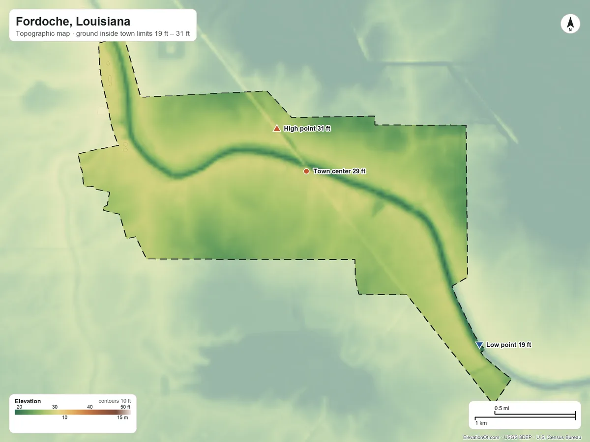
19 ft 6 m
on the southeast side
Highest
31 ft 9 m
near the middle
Average
27 ft 8 m
all land inside town limits
Fordoche is nearly flat: its ground varies by only about 12 ft, so the figures below sit close together.
| Figure | Elevation |
|---|---|
| Typical Where people live: half of residents higher, half lower | 27 ft8 m |
| Highest point Inside town limits, near the middle | 31 ft9 m |
| Lowest point Inside town limits, on the southeast side | 19 ft6 m |
| Town center USGS map point for Fordoche | 29 ft9 m |
| Average of all land | 27 ft8 m |
Topographic Map
- Location
- Town in Pointe Coupee Parish, Louisiana, United States
- Population
- 863 2024 est.
- Land area
- 2.4 sq mi
- Density
- 355 per sq mi
- Coordinates
- 30.5960° N, 91.6165° W
- Time zone
- Central UTC−6 / −5
- Landform region
- Coastal Plain
- Drains to
- Bayou Grosse Tete → Mississippi River → Gulf of America
- ZIP codes 1
- 70732
⤓ Download this map
WebP, 1200 × 900. Free to use: credit “ElevationOf.com” with a link to this page.
Sources: U.S. Census Bureau, USGS
Nearby Places
Nearby towns by typical elevation
- Morganza34 ft
- New Roads30 ft
- Melville29 ft
- Fordoche27 ft
- Ventress26 ft
- Livonia25 ft
- Krotz Springs23 ft
- Maringouin21 ft
- Erwinville20 ft
- Rosedale15 ft
- Grosse Tete15 ft
Rankings by typical elevation
- Towns in Louisiana288th highest of 481
- Towns in Pointe Coupee Parish3rd highest of 5
How we measure
- Typical elevation: the population-weighted median: every 2020 Census block inside the town limits, at its USGS 3DEP height, weighted by the people who live there. Half of residents live higher, half lower.
- Lowest, highest, average: USGS 3DEP bare-earth heights on a 1 arc-second (≈100 ft, 30 m) grid, land only, inside the Census town limits (TIGER, Jan 1 2026).
- Nearby Places: nearby towns and rankings use each town's typical elevation, so every town is compared like for like. Rankings count every city, town, township and census-designated place, including places inside a town. Peaks and hills: the nearest summits with at least 980 ft (300 m) of prominence within 62 mi (100 km), then federal (GNIS) summits within 16 mi (25 km) when there are fewer than 5; each is the 3DEP top on a ~7 ft (2 m) window, or the NGS published height when a usable survey mark sits within 160 ft (50 m) of it (shown as published).
- Rounding: computed heights are rounded to 10 ft (5 m), or to 1 ft (1 m) under 100 ft; 3DEP is good to about a meter, not a foot. Published figures (FAA airport elevation, NGS survey heights) are shown as their publisher gives them.
- Datum: North American Vertical Datum of 1988 (NAVD 88). NGS plans to replace NAVD 88 with a new datum (NAPGD2022); heights will then shift slightly.
- Sources: USGS 3DEP, GNIS, Watershed Boundary Dataset and physiographic provinces; U.S. Census Bureau (boundaries, 2020 blocks, 2024 population estimates, Gazetteer areas, ZIP code areas); BTS time zones. All public domain.