Alaska Elevation & Topographic Map
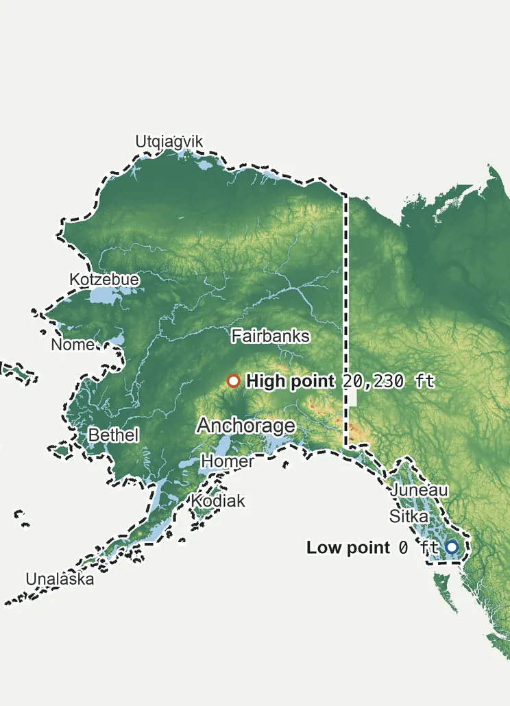
Elevation
20,230 ft 6,165 m15,170 ft 4,625 m12,640 ft 3,855 m7,590 ft 2,310 m2,530 ft 770 m0 ft 0 m
Zoom in for contour lines
USGS 3DEP · U.S. Census Bureau
How to use this mapviews, tools and data
- Elevation
- Ground colored by height from green (lowest) to white (highest), with contour lines every 40–500 ft (USGS data).
- Satellite
- A 2016 satellite photo at 33 ft (10 m) detail; contours off.
- 3D
- Tilt and turn the terrain; hills are raised 1.5×, or set ×1 for true height.
- Click or tap anywhere
- The exact elevation of that spot in ft and m.
- Measure
- Pick two points for the climb, descent and grade along a straight line.
- State area
- Fades everything outside the official state boundary (US Census).
Elevation Data
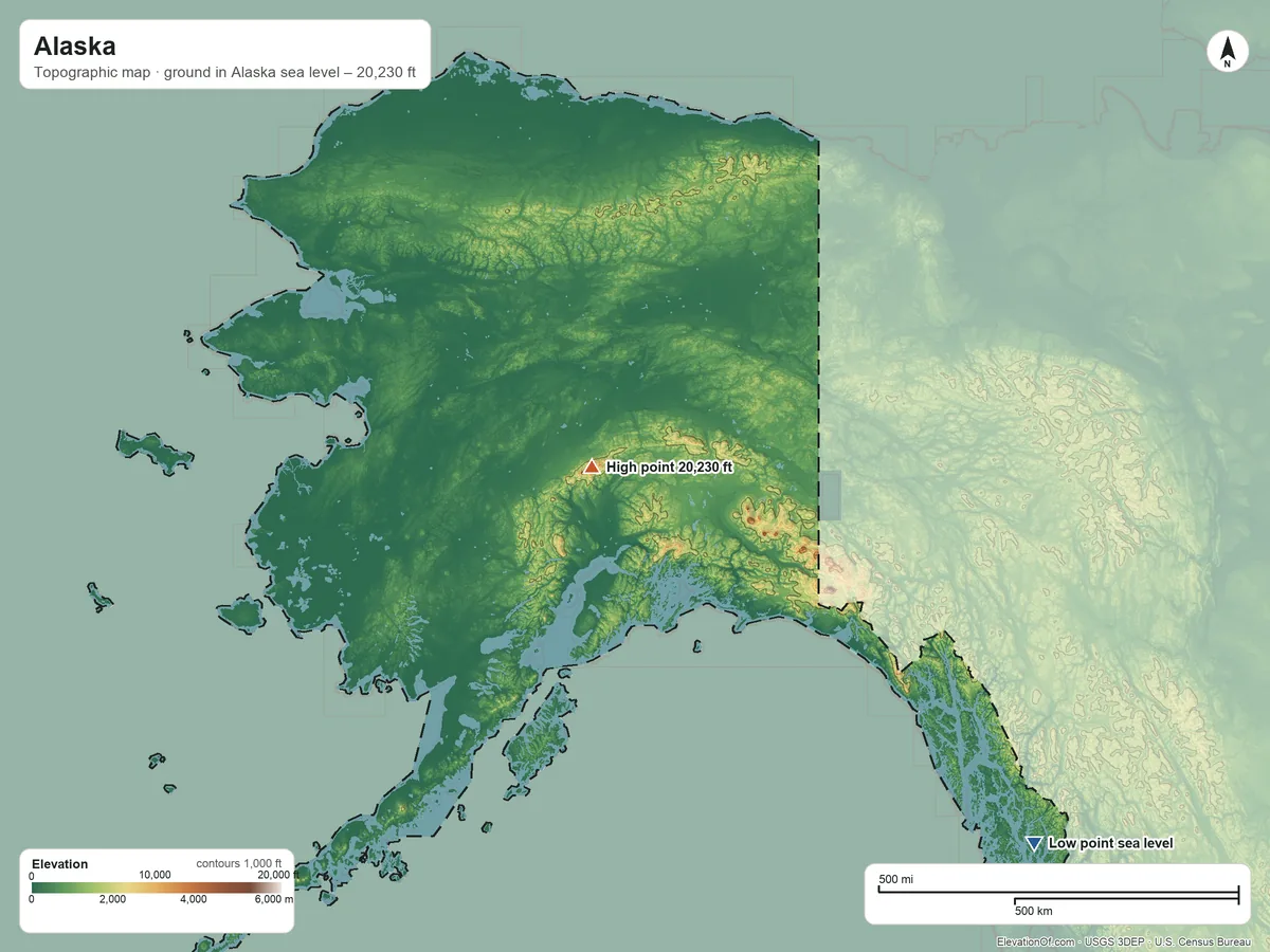
Alaska averages about 1,570 ft (480 m) above sea level across all its land. Its ground runs from sea level on George Inlet to 20,230 ft on Mount McKinley.
Average elevation
1,570 ft 480 m
all land in Alaska
Highest
20,230 ft 6,165 m
on Mount McKinley
Lowest
0 ft 0 m
at sea level on George Inlet
Alaska spans about 20,230 ft of height, so no single spot tells the whole story. The ruler shows where most of its land lies, and where the other numbers you'll see come from.
| Figure | Elevation |
|---|---|
| Average of all land | 1,570 ft480 m |
| Highest point In Alaska, on Mount McKinley (3DEP terrain model; no NGS survey height) | 20,230 ft6,165 m |
| Lowest point Where the land meets George Inlet | 0 ft0 m |
Elevation profile, west to east
821 mi west to east through Anchorage.
Topographic Map
- Location
- State in the Pacific division of the West region, United States
- Population
- 740,133 2024 est.
- Land area
- 571,409.1 sq mi + 94,315.8 sq mi water
- Density
- 1 per sq mi
- Boroughs and census areas
- 26
- Time zone
- Alaska UTC−9 / −8
- Drains to
- Bering Sea 57%, Norton Sound 14%
⤓ Download this map
WebP, 1200 × 900. Free to use: credit “ElevationOf.com” with a link to this page.
Sources: U.S. Census Bureau, USGS
Nearby Places
Neighboring states nearest, by average
- Idaho5,270 ft
- Oregon3,540 ft
- Washington2,320 ft
- Alaska1,570 ft
Rankings by average elevation
- States in the United States19th highest of 52
Peaks and hills highest inside
- Mount McKinley20,230 ft
- Mount Foraker17,360 ft
- Mount Bona16,370 ft
- Mount Blackburn16,360 ft
- Mount Sanford16,230 ft
All 26 boroughs and census areas by average elevation
- Copper River Census Area4,270 ft
- Skagway Municipality3,700 ft
- Matanuska-Susitna Borough2,930 ft
- Southeast Fairbanks Census Area2,900 ft
- Haines Borough2,730 ft
- Denali Borough2,730 ft
- Yakutat City and Borough2,510 ft
- Chugach Census Area2,320 ft
- Petersburg Borough2,250 ft
- Kenai Peninsula Borough1,980 ft
- Hoonah-Angoon Census Area1,910 ft
- Ketchikan Gateway Borough1,740 ft
- Fairbanks North Star Borough1,660 ft
- North Slope Borough1,460 ft
- Yukon-Koyukuk Census Area1,240 ft
- Kodiak Island Borough1,040 ft
- Lake and Peninsula Borough1,020 ft
- Northwest Arctic Borough980 ft
- Aleutians West Census Area850 ft
- Bethel Census Area800 ft
- Prince of Wales-Hyder Census Area770 ft
- Dillingham Census Area710 ft
- Aleutians East Borough650 ft
- Nome Census Area590 ft
- Kusilvak Census Area200 ft
- Bristol Bay Borough150 ft
All 222 tribal lands by average elevation
- Chickaloon ANVSA3,870 ft
- Chitina ANVSA3,430 ft
- Mentasta Lake ANVSA2,830 ft
- Cantwell ANVSA2,810 ft
- Skagway ANVSA2,700 ft
- Tanacross ANVSA2,490 ft
- Anaktuvuk Pass ANVSA2,230 ft
- Arctic Village ANVSA2,060 ft
- Chistochina ANVSA1,950 ft
- Tetlin ANVSA1,770 ft
- Gakona ANVSA1,760 ft
- Northway ANVSA1,750 ft
- Eagle ANVSA1,520 ft
- Gulkana ANVSA1,430 ft
- Healy Lake ANVSA1,430 ft
- Dot Lake ANVSA1,400 ft
- Tazlina ANVSA1,300 ft
- Copper Center ANVSA1,220 ft
- Douglas ANVSA1,190 ft
- Port Alsworth ANVSA1,080 ft
- Knik ANVSA1,080 ft
- Port Lions ANVSA1,010 ft
- Chignik Lagoon ANVSA850 ft
- Ivanof Bay ANVSA850 ft
- Ninilchik ANVSA830 ft
- Canyon Village ANVSA830 ft
- Lake Minchumina ANVSA820 ft
- Kenaitze ANVSA810 ft
- Port Graham ANVSA760 ft
- Lime Village ANVSA760 ft
- Takotna ANVSA750 ft
- Circle ANVSA750 ft
- Inalik ANVSA750 ft
- Unalaska ANVSA730 ft
- Rampart ANVSA710 ft
- Nanwalek ANVSA710 ft
- Tatitlek ANVSA700 ft
- Kodiak ANVSA680 ft
- Georgetown ANVSA670 ft
- Kasaan ANVSA650 ft
- Crooked Creek ANVSA650 ft
- Evansville ANVSA650 ft
- Telida ANVSA650 ft
- King Cove ANVSA640 ft
- Annette Island Reserve630 ft
- Karluk ANVSA600 ft
- Chignik ANVSA600 ft
- Venetie ANVSA590 ft
- Akutan ANVSA590 ft
- Seldovia ANVSA580 ft
- Alatna ANVSA580 ft
- Hoonah ANVSA570 ft
- Ketchikan ANVSA570 ft
- Pedro Bay ANVSA560 ft
- Ruby ANVSA540 ft
- Red Devil ANVSA520 ft
- Chalkyitsik ANVSA520 ft
- Chenega ANVSA520 ft
- Manley Hot Springs ANVSA510 ft
- Nondalton ANVSA480 ft
- Old Harbor ANVSA480 ft
- Allakaket ANVSA460 ft
- Saxman ANVSA450 ft
- Napaimute ANVSA450 ft
- Fort Yukon ANVSA440 ft
- Craig ANVSA430 ft
- Birch Creek ANVSA430 ft
- Nikolai ANVSA430 ft
- Eyak ANVSA420 ft
- Chignik Lake ANVSA420 ft
- Hughes ANVSA410 ft
- Minto ANVSA410 ft
- Tununak ANVSA400 ft
- McGrath ANVSA390 ft
- False Pass ANVSA370 ft
- Angoon ANVSA370 ft
- St. George ANVSA370 ft
- Akhiok ANVSA370 ft
- Nenana ANVSA370 ft
- Grayling ANVSA370 ft
- Beaver ANVSA360 ft
- Belkofski ANVSA360 ft
- Pitkas Point ANVSA340 ft
- Ouzinkie ANVSA340 ft
- Nulato ANVSA330 ft
- Chilkat ANVSA330 ft
- Uyak ANVSA330 ft
- Tanana ANVSA320 ft
- Stevens Village ANVSA310 ft
- Platinum ANVSA300 ft
- Council ANVSA290 ft
- Iliamna ANVSA290 ft
- Larsen Bay ANVSA290 ft
- Elim ANVSA280 ft
- Nightmute ANVSA280 ft
- Kake ANVSA280 ft
- Kobuk ANVSA280 ft
- Manokotak ANVSA250 ft
- Sitka ANVSA250 ft
- Sleetmute ANVSA240 ft
- Koyukuk ANVSA240 ft
- Unalakleet ANVSA240 ft
- New Koliganek ANVSA240 ft
- Kaltag ANVSA240 ft
- Kokhanok ANVSA230 ft
- Sand Point ANVSA230 ft
- Atka ANVSA220 ft
- Stony River ANVSA220 ft
- New Stuyahok ANVSA220 ft
- Wales ANVSA210 ft
- Gambell ANVSA200 ft
- Togiak ANVSA200 ft
- Pilot Station ANVSA190 ft
- Newtok ANVSA190 ft
- Huslia ANVSA190 ft
- Andreafsky ANVSA190 ft
- Aleknagik ANVSA180 ft
- Algaaciq ANVSA180 ft
- Ambler ANVSA180 ft
- Chuathbaluk ANVSA170 ft
- Russian Mission ANVSA160 ft
- Holy Cross ANVSA160 ft
- Kalskag ANVSA150 ft
- Noatak ANVSA150 ft
- Galena ANVSA150 ft
- Kiana ANVSA150 ft
- Nome ANVSA140 ft
- Ohogamiut ANVSA140 ft
- Koyuk ANVSA140 ft
- Tyonek ANVSA140 ft
- Chilkoot ANVSA140 ft
- South Naknek ANVSA130 ft
- Goodnews Bay ANVSA130 ft
- Shungnak ANVSA130 ft
- Wrangell ANVSA120 ft
- St. Paul ANVSA120 ft
- Ekwok ANVSA120 ft
- Nikolski ANVSA120 ft
- Savoonga ANVSA110 ft
- Ekuk ANVSA110 ft
- Igiugig ANVSA110 ft
- Newhalen ANVSA110 ft
- Marshall ANVSA110 ft
- Scammon Bay ANVSA110 ft
- Paimiut ANVSA100 ft
- Salamatof ANVSA100 ft
- Anvik ANVSA100 ft
- Portage Creek ANVSA99 ft
- Yakutat ANVSA97 ft
- Dillingham ANVSA92 ft
- Toksook Bay ANVSA89 ft
- Naknek ANVSA87 ft
- Aniak ANVSA84 ft
- Shageluk ANVSA81 ft
- Lesnoi ANVSA81 ft
- Kotzebue ANVSA80 ft
- Clarks Point ANVSA76 ft
- Perryville ANVSA75 ft
- Petersburg ANVSA72 ft
- Port Heiden ANVSA72 ft
- King Salmon ANVSA68 ft
- Atqasuk ANVSA64 ft
- Deering ANVSA63 ft
- White Mountain ANVSA61 ft
- Hydaburg ANVSA61 ft
- Lower Kalskag ANVSA57 ft
- Teller ANVSA57 ft
- St. Michael ANVSA56 ft
- Bethel ANVSA55 ft
- Eklutna ANVSA54 ft
- Ugashik ANVSA54 ft
- Levelock ANVSA53 ft
- Egegik ANVSA50 ft
- Mountain Village ANVSA50 ft
- Mekoryuk ANVSA49 ft
- Klawock ANVSA45 ft
- Pilot Point ANVSA44 ft
- Stebbins ANVSA42 ft
- Golovin ANVSA42 ft
- Brevig Mission ANVSA41 ft
- Kaktovik ANVSA41 ft
- Wainwright ANVSA39 ft
- Twin Hills ANVSA37 ft
- Noorvik ANVSA36 ft
- Chevak ANVSA35 ft
- Tuluksak ANVSA32 ft
- Shishmaref ANVSA31 ft
- Kasigluk ANVSA30 ft
- Barrow ANVSA29 ft
- Nuiqsut ANVSA27 ft
- Point Lay ANVSA26 ft
- Akiak ANVSA26 ft
- Kwethluk ANVSA22 ft
- Kongiganak ANVSA21 ft
- Akiachak ANVSA20 ft
- Buckland ANVSA20 ft
- Kwinhagak ANVSA20 ft
- Napakiak ANVSA17 ft
- Point Hope ANVSA17 ft
- Eek ANVSA17 ft
- Nunapitchuk ANVSA15 ft
- Chefornak ANVSA14 ft
- Hamilton ANVSA14 ft
- Shaktoolik ANVSA14 ft
- Napaskiak ANVSA14 ft
- Oscarville ANVSA14 ft
- Emmonak ANVSA13 ft
- Bill Moore's ANVSA13 ft
- Selawik ANVSA12 ft
- Mary's Igloo ANVSA12 ft
- Chuloonawick ANVSA12 ft
- Nelson Lagoon ANVSA11 ft
- Alakanuk ANVSA11 ft
- Hooper Bay ANVSA11 ft
- Atmautluak ANVSA11 ft
- Tuntutuliak ANVSA11 ft
- Kwigillingok ANVSA11 ft
- Solomon ANVSA10 ft
- Kipnuk ANVSA10 ft
- Nunam Iqua ANVSA9 ft
- Kotlik ANVSA9 ft
- Kivalina ANVSA8 ft
How we measure
- Average: every USGS 3DEP bare-earth cell of land inside the Census state boundary (TIGER/Line, Jan 1 2026), weighted equally, on a 44 arc-second (≈4,460 ft, 1,358 m) grid, coarsened from 1 arc-second so the whole area fits one run. Land means the boundary minus Census area water (on this grid, water areas of at least half a cell).
- Highest and lowest: the highest land cell, re-read at 1 arc-second around the 25 highest grid cells; it is a named summit, so its height is the peak method: the 3DEP top on a ~7 ft (2 m) window, or the NGS published height when a survey mark sits within 160 ft (50 m) of it. Lowest: the lowest land cell, re-read at 1 arc-second around the 25 lowest grid cells; coastal ground within 3 ft (1 m) of named tidal water counts as sea level.
- Pits: the lowest point is the lowest ground outside closed hollows (quarry floors, mine pits, terrain-model artifacts): any hollow under 0.4 sq mi (1 km²), and any hollow under 2 sq mi (5 km²) whose floor is more than 100 ft (30 m) below its rim; and outside patches below sea level of under 0.4 sq mi (1 km²). The single lowest 3DEP cell, −65 ft at 70.2974° N, 148.5204° W, is in such a hollow or patch and is not counted; this coastal land's lowest point is sea level on the coast.
- Nearby Places: neighboring states and rankings use each one's average elevation, on its own grid, the same figure its page shows. Peaks and hills: the highest summits inside the state with at least 980 ft (300 m) of prominence, then the highest federal (GNIS) summits inside it when there are fewer than 5; each is the 3DEP top on a ~7 ft (2 m) window, or the NGS published height when a usable survey mark sits within 160 ft (50 m) of it (shown as published).
- Boroughs and census areas: each one's average on its own grid (1 arc-second, coarser for the largest), the same figure its own page shows.
- Rounding: computed heights are rounded to 10 ft (5 m), or to 1 ft (1 m) under 100 ft; 3DEP is good to about a meter, not a foot. Published figures (NGS survey heights) are shown as their publisher gives them.
- Alaska: much of Alaska's 3DEP comes from airborne radar (IfSAR), good to a few meters. The Aleutian islands west of 180° are counted; the map leaves them out of the opening view.
- Datum: North American Vertical Datum of 1988 (NAVD 88). NGS plans to replace NAVD 88 with a new datum (NAPGD2022); heights will then shift slightly.
- Sources: USGS 3DEP, GNIS, Watershed Boundary Dataset and physiographic provinces; U.S. Census Bureau (TIGER boundaries and water, 2020 blocks, 2024 population estimates, county adjacency); NOAA NGS survey heights; BTS time zones. All public domain.