Pointe-au-Chien SDTSA, LA Elevation & Topographic Map
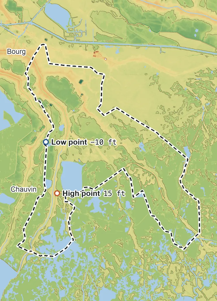
Elevation
23 ft 7 m15 ft 5 m11 ft 3 m2 ft 1 m−6 ft −2 m−10 ft −3 m
Contours every 200 ft, bold every 1,000 ft
USGS 3DEP · U.S. Census Bureau
How to use this mapviews, tools and data
- Elevation
- Ground colored by height from green (lowest) to white (highest), with contour lines every 40–500 ft (USGS data).
- Satellite
- A 2016 satellite photo at 33 ft (10 m) detail; contours off.
- 3D
- Tilt and turn the terrain; hills are raised 1.5×, or set ×1 for true height.
- Click or tap anywhere
- The exact elevation of that spot in ft and m.
- Measure
- Pick two points for the climb, descent and grade along a straight line.
- Area
- Fades everything outside the official statistical area boundary (US Census).
Elevation Data
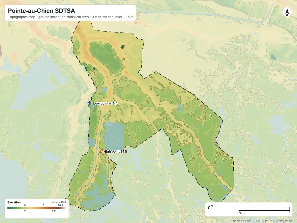
Pointe-au-Chien SDTSA averages about 0 ft (0 m) above sea level across all its land. Its ground runs from 10 ft below sea level on the west side to 15 ft on the southwest side.
Average elevation
0 ft 0 m
all land inside the statistical area
Highest
15 ft 5 m
on the southwest side
Lowest
−10 ft −3 m
on the west side
Pointe-au-Chien SDTSA is nearly flat: its ground varies by only about 25 ft, so the figures below sit close together.
69% of Pointe-au-Chien SDTSA's land lies below the average daily high tide (MHHW, NOAA), and 29% lies less than 3 ft above it. Check flood zones on FEMA's map
| Figure | Elevation |
|---|---|
| Average of all land | 0 ft0 m |
| Highest point Inside the statistical area, on the southwest side | 15 ft5 m |
| Lowest point Inside the statistical area, on the west side | −10 ft−3 m |
Topographic Map
- Location
- State designated tribal statistical area in Louisiana, United States (U.S. Census Bureau)
- Population
- 4,579 2020 Census
- Land area
- 52.3 sq mi + 5.0 sq mi water
- Density
- 88 per sq mi
- Time zone
- Central UTC−6 / −5
- Landform region
- Coastal Plain
- Drains to
- Gulf of America
⤓ Download this map
WebP, 1200 × 900. Free to use: credit “ElevationOf.com” with a link to this page.
Sources: U.S. Census Bureau, USGS
Nearby Places
Nearest tribal lands nearest, by average
- Chitimacha Reservation11 ft
- Isle de Jean Charles SDTSA5 ft
- United Houma Nation SDTSA2 ft
- Pointe-au-Chien SDTSA0 ft
- Grand Caillou/Dulac SDTSA−1 ft
- Bayou Lafourche SDTSA−2 ft
Rankings by average elevation
- Tribal lands in Louisiana12th highest of 14
- Tribal lands in the United States699th highest of 704
The one town in the statistical area
- Montegut1 ft
How we measure
- Average: every USGS 3DEP bare-earth cell of land inside the Census statistical area boundary (TIGER/Line AIANNH, Jan 1 2026), weighted equally, on a 1 arc-second (≈100 ft, 30 m) grid. Land means the boundary minus Census area water.
- Highest and lowest: the highest land cell. Lowest: the lowest land cell; coastal ground within 3 ft (1 m) of named tidal water counts as sea level.
- Pits: the lowest point is the lowest ground outside closed hollows (quarry floors, mine pits, terrain-model artifacts): any hollow under 0.4 sq mi (1 km²), and any hollow under 2 sq mi (5 km²) whose floor is more than 100 ft (30 m) below its rim; and outside patches below sea level of under 0.4 sq mi (1 km²). The single lowest 3DEP cell, −28 ft at 29.5282° N, 90.5404° W, is in such a hollow or patch and is not counted.
- Name: the Census Bureau's legal or statistical area name, as published; the nation's own name may differ.
- Population: 2020 Census residents of the blocks inside the boundary.
- Nearby Places: nearest tribal lands and rankings use each one's average elevation, on its own grid, the same figure its page shows. Peaks and hills: the highest summits inside the statistical area with at least 980 ft (300 m) of prominence, then the highest federal (GNIS) summits inside it when there are fewer than 5; each is the 3DEP top on a ~7 ft (2 m) window, or the NGS published height when a usable survey mark sits within 160 ft (50 m) of it (shown as published).
- Towns: each town's typical elevation (population-weighted median of its own 2020 blocks at 1 arc-second); a town is listed when any of its 2020 residents live in the statistical area.
- Rounding: computed heights are rounded to 10 ft (5 m), or to 1 ft (1 m) under 100 ft; 3DEP is good to about a meter, not a foot. Published figures (NGS survey heights) are shown as their publisher gives them.
- Datum: North American Vertical Datum of 1988 (NAVD 88). NGS plans to replace NAVD 88 with a new datum (NAPGD2022); heights will then shift slightly.
- Sources: USGS 3DEP, GNIS, Watershed Boundary Dataset and physiographic provinces; U.S. Census Bureau (TIGER boundaries and water, 2020 blocks); NOAA NGS survey heights; BTS time zones; NOAA tidal surfaces (MHHW). All public domain.